Canadian Tectonics Group Workshop
Tyax Lodge, Goldbridge, B.C.
18 –22 October 2002
PROGRAM & ABSTRACTS
9:30 Tom Gleeson and Laurent Godin
The Chako Antiform: Expanding our understanding of the metamorphic core of the Himalayan Orogen
10:00 John Starkey
Chemical changes and the development of quartz preferred orientation in zones of crenulation cleavage, Anglesey.
10:30 Pierre Nadeau and Laurent Godin
Microstructural and Geochronological Investigation of the Innukjuak domain, Northeast Superior Province, Northern Quebec
11:00 Steve Israel and Lori Kennedy
Geology of the Atnarko Metamorphic Complex
11:30 Jim Ryan, Steve Gordey, Mike Villeneuve and Steve Piercey
Composition and evolution of YukonTanana Terrane
in the Stewart River area, Yukon Territory
Lunch.
1:30 Simony, P.S. and Reid, L.F.
The Tighe Creek Laccolith; A Blister On A Sill
2:00 Mike Henrichson and Lori Kennedy
Structural geology of the Stanley Head region, Cornwallis Island, Nunavit
2:30 Steve Quane and Kelly Russell
An Objective Classification of Welding Intensity in Pyroclastic Deposits
3:00 Robert Stetsky
FAULTSLIP: A New Windows Application for Analysing Slickenside and Earthquake Fault Plane Data
3:30 Lori Kennedy, Kelly Russell and Maya Kopylova
Mantle shear zones revisited – the connection between the cratons and mantle dynamics
4:00 First field stop
Low Temperature Deformation of Dolomite
Nick Austin and Lori Kennedy, Earth and Ocean Sciences, 6339 Stores Rd, University of British Columbia, Vancouver BC, V6T 1Z4 (previously presented at GAC/MAC 2002)
The rheological behaviour of dolomite under varying physical conditions is poorly quantified. Here, we experimentally investigate the role of pore fluid pressure, confining pressure, temperature, and strain rate on the fracture strength and permeability of dolomite. The mechanical and microstructural data obtained will improve our understanding of the strength and fracture controlled permeability of both dolomite rich thrust sheets and dolomite hosted oil and gas reservoirs.
Previous studies regarding the effects of confining pressure, temperature, and strain rate (Handin et al., 1967; Handin and Fairbairn, 1955) on the strength of dolomite indicate that decreasing strain rate or increasing confining pressure decreases the temperature at the brittle/ductile transition. The role of pore fluid pressure has not yet been defined.
Our experimental program uses the newly established Large Sample Rig (LSR), a triaxial rock press housed at UBC. The LSR has an argon confining medium, an independent pore fluid pressure - flow through system, and an internal furnace. Strain rates can range from 10–3 s-1 to 10–8 s-1. Samples are right cylinders 47mm in diameter, and 96mm long (~2:1 ratio). Suites of experiments have been established to isolate individual variables, including confining pressure, pore fluid pressure and temperature. Dry samples are prepared by baking selected cores at 85oC for 24 hours, while saturated samples are prepared by submerging the sample in distilled H2O for a minimum of 48 hours.
The starting material is dolomitic marble from the Badshot-Mochian formation in southeastern British Columbia, which consists of pure dolomite, with local tremolite porphyroblasts. The average initial grain area is 3.5 X 10⁵ _m2, with an average major/minor axis ratio of 2.33, but no preferred orientation. This corresponds to an average grain length of ~670 _m. Grain size analysis was performed using image analysis software from the Scion Corporation®.
Initial results show that the ultimate strength of unconfined, dry dolomite is 163 MPa and 176 MPa at a strain rate of 10-4 s-1, and 113 MPa and 176 MPa at 10-5 s-1; saturated, the strength is 130 MPa and 137 MPa at 10-4 s-1, and 116 MPa and 133 MPa at 10-5 s-1.
Future experiments will examine the impact of elevated pore fluid pressure, confining pressure, and temperature on the ultimate strength, fracture geometry, permeability, and microstructural development of dolomite. From this data, a constitutive relationship relating the experimental variables will be established.
Structural Attitudes of Large Scale Layering in Valles Marineris, Mars, from Analysis of Imagery and Altimetry Data
Frank Fueten, Brock University, St. Catharines, ON
Robert M. Stesky, Pangaea Scientific, Brockville, ON
Jennifer Marsh, Brock University, St. Catharines, ON
Valles Marineris, a 4000 km. long, 700 km wide and 7km deep canyon on the flank of the Tharsis Ridge uplift on Mars, exposes strata along its walls. We combined Mars Orbiter Laser Altimiter (MOLA) elevation data with Mars Orbiter Camera (MOC) images using our Orion structural analysis software to compute the attitude of the large scale layering. Registration of these two data sets proved to be difficult due to differences in the Martian projection models used to construct the data of the two instruments. At present we are able to use only the relatively lowresolution 256 pixels/degree (231.5m/pixel) data, rather than the much higher resolution images available. Ultimately, the results will be limited by the resolution of the MOLA data, for which the instrument is no longer functioning.
Initial results from 109 attitude calculations indicate that layers are generally predictably shallow, with dips of less than 10 degrees and strikes that are sub-parallel to canyon walls. While local variations exist, there are regions where the data appears to be relatively consistant over the scale of hundreds of kilometers. This suggests that at least some of the data reflects the orientation of strata and is not solely a result of data artifacts. The use of Orion to combine MOLA and MOC data shows promise and more work will be directed at adapting higher resolution image data. It may therefore be possible to determine the large scale structure of Valles Marineris prior to making a manned mission.
The Chako Antiform: Expanding our understanding of the metamorphic core of the Himalayan Orogen
TOM GLEESON and LAURENT GODIN, Department of Earth Sciences, Simon Fraser University, Burnaby, BC, Canada V5A 1S6
e-mail: tpg@sfu.ca
The metamorphic core of the Himalayan orogen is composed of Proterozoic basement rocks of the Indian Plate, called the Greater Himalayan metamorphic series (GHMS). Understanding the distribution of lithologies, metamorphism, and deformation within this metamorphic core is crucial to constraining the timing of tectono-thermal events and exhumation processes. The gneisses of the GHMS are a south-facing, homoclinal slab of high-grade gneiss, typically divided into three formations. The GHMS is structurally overlain by the low-grade Tethyan sedimentary sequence, which represents the northern passive margin of the Indian paleocontinent. The contact between the GHMS and Tethyan sedimentary sequence is the South Tibetan detachment system (STDS; .
The Chako gneisses outcrop in the Nar Valley, north of the Annapurna massif in central Nepal. Reconnaissance mapping recognised an enigmatic domal structure of GHMS gneiss, surrounded by rocks correlated with the Tethyan Sedimentary Sequence, . The structure was called the Chako Dome. A new 1:50,000-scale map of the Nar Valley with a significant re-interpretation is presented. The map area is divided into three different structural levels: a lower level of granitic augen gneiss interlayered with biotite schist and hornblende-biotite-arkose schist (Level 1), an intermediate level of biotite-marble schist and garnet-biotite gneiss and schist (Level 2), and an upper level of unmetamorphosed limestone and shale (Level 3; . This presentation focuses on the metamorphic rocks of Levels 1 and 2. Lithologically and petrographically, Level 1 correlates well with the well-studied GHMS of the Annapurna area. The rocks of Level 2, previously mapped as the sub-greenschist or zeolite facies Tethyan sedimentary sequence, consist exclusively of gneisses and schists, in part at garnet grade. This suggests that Level 2 is a previously undescribed component to the GHMS rather than part of the Tethyan sedimentary sequence, and that the South Tibetan detachment system marks the boundary between Levels 2 and 3. Ongoing Grt-Bt thermometry will elucidate peak metamorphic temperatures.
Levels 1 and 2 contain a pervasive schistosity (S1) overprinted by asymmetric folds, rotated porphoryblasts, and boudinaged and rotated dykes with an associated elongation lineation (D2). D2 shear-sense indicators suggest predominantly south-verging deformation within the gneiss package, similar to the GHMS. A gently west-plunging antiform-synform pair warps the entire package on a regional scale. The antiform, combined with valley incision, creates an apparent dome. However, there are no east-dipping foliations to suggest this is a doubly-plunging anticline. We therefore prefer the term Chako antiform rather than Chako Dome.
The lithologies, metamorphic grade, and structures all suggest these rocks are part of the Greater Himalayan metamorphic series. This re-interpretation expands the GHMS northward to include rocks previously considered to be Tethyan sedimentary sequence. Furthermore, this detailed work reveals that the GHMS is more lithologically diverse and complex than a simple three formation slab and it is warped on a regional scale.
Bibliography:
Structural geology of the Stanley Head region, Cornwallis Island, Nunavit
Michael Henrichson and Lori Kennedy Earth and Ocean Sciences, 6339 Stores Road, University of British Columbia, Vancouver BC. V6T 1Z4
The structural geology of the Stanley Head region of western Cornwallis Island, located within the Cornwallis Fold Belt, is characterized by thin-skinned fold and thrust style structures, that have developed on low strength evaporitic detachments. The structures found in this region have some of the characteristic elements of evaporite based thin-skinned contractional deformation (Davis and Engelder, 1985), and can be explained and interpreted using a kinematic model of deformation developed by Harrison and Bally (1988) for eastern Melville Island. In an attempt to characterize the structure geology of the Stanley Head region, a geologic map and a representative structural cross section, that transect the study area, will be presented. The cross section has been constructed from the integration of surficial structural data and a theoretical kinematic model of deformation in a multiple detachment evaporite based fold and thrust belt. It is proposed that there are fundamental differences between the documented and exposed Stanley Head anticline and an underlying fold and thrust belt.
Mantle shear zones revisited: The connection between the cratons and mantle dynamics
Lori A. Kennedy, J. Kelly Russell, Maya G. Kopylova
Department of Earth and Ocean Science, Geological Sciences Building,
University of British Columbia, Vancouver, British Columbia V6T 1Z4, Canada
Past studies of mantle xenoliths have shown cratonic mantle lithosphere to contain two texturally distinct types of peridotite: protogranular peridotite and porphyroclastic (sheared) peridotite. The protogranular peridotite displays microstructure and fabrics associated with steady-state mantle processes, (e.g., Green and Guegen, 1974, Harte, 1977), whereas porphyroclastic peridotite records evidence of differential stresses and strain rates of formation that are considered too high to represent steady-state mantle conditions (Green and Guegen, 1974; Goetze, 1975; Mercier, 1979). The origins of porphyroclastic peridotite are enigmatic, and a variety of models have been proposed; however, none is entirely satisfactory.
New geodynamic models, based on teleseismic data sets, propose that the westward motion of the North and South American plates is driven by asthenospheric flow coupled to the overlying lithosphere. Implicit in these models is the existence of a zone of partial coupling at the boundary between the lithosphere and asthenosphere. We propose that porphyroclastic peridotite xenoliths from kimberlite are samples of deep-mantle shear zones. These samples are a direct manifestation of the mechanical coupling that arises from the drag applied to the lithosphere by the underlying asthenospheric flow. We postulate that the formation of shear zones at the lithosphere-asthenosphere boundary is a quasi-steady-state process attending plate movement beneath all cratons.
Shear zone foliations as discriminators of geometric, kinematic and mechanical responses
Ellie MacInnes and Joseph Clancy White
Department of Geology, University of New Brunswick
Fredericton NB E3B 5A3
[Previously presented September 2nd 2002, “Transport and Flow Processes in Shear Zones”, Geol. Soc. Lond.]
In large-scale, complex and long-lived high-strain zones distinct types of foliations form as multiple generations in response to changing conditions; for example, changes that occur during transitions between brittle and ductile deformation, hydromechanical fluctuations producing veins and alterations in the external tectonic framework. Materially, temporally and spatially distinct foliations are formed throughout the fault zone history and produce intricate overprinting relationships. The outward complexity of such foliation arrays enables their use as discriminators of geometric, kinematic and mechanical responses within large-scale shear zones. The Minas fault zone (MFZ) in Nova Scotia, Canada is used to highlight the utility of shear zone structure to such discrimination.
A large data set comprising foliation type, orientation, geometric history and timing relationships was collected from the core high-strain zone. The foliations act as markers that highlight sequential development, relative displacement and mechanism of strain accommodation. Detailed examination of the foliations demonstrates the necessity for precursor high-strain fabrics (transposed foliations) in order for well-defined kinematic markers (S-C fabrics) and mechanically controlled displacement markers (shear band foliations) to develop. An important consequence of the multiple foliation development is the ability to discriminate fundamental kinematically defined features from mechanically initiated features that evolve to give kinematic evidence.
There is a general progression from ductile through semi-brittle to brittle deformation as the fault zone evolves. Nevertheless, deviations in mechanical response from the deformation regime dominant at any one time are legion. Localization, partitioning and distribution of deformation routinely reflect these deviations, and are in turn factors which influence the type and orientation of foliation or planar feature produced; for example, shear bands vs Riedel shears and compositional layering vs fault gouge. The variable response of the shear zone rocks to otherwise presumed constant bulk imposed conditions emphasizes the heterogeneity of behaviour within shear zones. The latter is displayed as rapidly varying strain rates and deformation mechanisms that must in turn be related to position of a specific fabric within its evolutionary cycle. Despite the geometric complexities observed, both large-scale and long-lived consistency amongst the kinematic indicators can be demonstrated when they are carefully discriminated. Specifically, a high degree of correlation that corresponds to the regional tectonic movement picture is demonstrable amongst ductile, brittle and transitional deformation features.
Microstructural and Geochronological Investigation of the Innukjuak domain, Northeast Superior Province, Northern Quebec
Pierre Nadeau & Laurent Godin
Department of Earth Sciences, Simon Fraser University, British Columbia
High grade metamorphic rocks often exhibit complex fabrics from magmatic and/or tectonic deformation. These fabrics are often misinterpreted, leading to confusion about the relative chronological importance of processes at work during solid-state and magmatic deformation of rocks. The principal objective of this study is to address this problem by undertaking a study of outcrops that show complex magmatic and tectonic fabrics. The study involves a detailed examination of three outcrops in the vicinity of Innuksuac River in the northeast Archean Superior Province; one outcrop dominated by supracrustal rocks (TookTook), and two outcrops dominated by granitic rocks (Okalik I and II). The first phase of work, completed during the summer 2001, identified six deformation phases. The first deformation phase (D1) is characterized by a compositional layering (S 0-1) in xenoliths of Okalik I and II, and in the supracrustal rocks of TookTook. The second phase of deformation (D2) is characterized by tight to isoclinal folds (F2) in the xenoliths of Okalik I and II. At TookTook, these folds are discontinuous, with preserved hinges and transposed limbs. The third phase of deformation (D3) is characterized by a magmatic foliation (S3), only visible in the Okalik sites. This phase is most probably coeval with the intrusion of pegmatite dykes crosscutting the supracrustal rocks. The fourth phase of deformation (D4) is marked by the presence of folds (F4) affecting S3 fabric in the granitic rocks. At TookTook, D4 is outlined by large open folds of the pegmatite dykes. The fifth deformation phase (D5) is characterized by the presence of discrete ductile shears observed only at Okalik I, and by a crenulation cleavage at the TookTook site. Late brittle-ductile faults and quartz/carbonate veins define the sixth deformation phase (D6). A U-Pb geochronological study is currently underway on six samples to help constrain the timing of the different deformation phases. This is accompanied by a microstructural study to characterize the different processes at work in these rocks. This study will bring invaluable information on the tectonic and magmatic evolution of the northeast Superior Province.
An Objective Classification of Welding Intensity in Pyroclastic Deposits
Steven L. Quane & J.K. Russell
Igneous Petrology Lab UBC
Pyroclastic deposits emplaced at high temperatures and having sufficient thickness become welded. The welding process involves sintering, compaction and flattening of hot glassy pyroclastic material, and it occurs at temperatures above the material's glass transition temperature (Tg) (e.g., Smith, 1979; Ross & Smith. 1980; Cas & Wright, 1987; Gottsmann & Dingwell, 1999; Giordano et al., 2000). Pronounced changes in physical properties attend welding (Fig. 1); as welding intensifies, for example, primary porosity is reduced and density increases (e.g., Ragan & Sheridan, 1972; Streck & Grunder, 1995; Rust & Russell, 2000). In general, the intensity of welding reflects the aggregate effects of the load of the overlying column of pyroclastic deposit and time of residence at temperatures above Tg (Ross & Smith, 1980; Riehle et al., 1995). Consequently, welding intensity in individual deposits generally varies with stratigraphic depth (Fig. 1). A simple cooling unit of pyroclastic material has zones of unwelded material at the top and bottom due to significantly fast cooling to the air and ground respectively. Welding intensity increases up and down section to a maximum at about 40% above the base of the deposit, roughly corresponding to the results of conductive cooling models for a package of pyroclastic material emplaced on a rock substrate (Riehle, 1973).
Historically, the terms nonwelded, incipiently welded, partially welded w/pumice, partially welded w/fiamme, moderately welded and densely welded have been used as field descriptors for welding intensity (e.g., Smith & Bailey, 1966; Smith, 1979; Ross & Smith, 1980; Streck & Grunder, 1995). While this method is effective for describing variations within a single study, its qualitative character does not provide a universal consistency between field areas or workers.
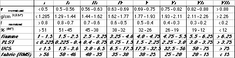
Here we develop an objective classification system consisting of welding indices from I-VIII (Table 1). The classification system is based on normalized physical property measurements making it universal for all welded pyroclastic deposits. The physical property measurements are both field (fiamme elongation & point load strength (PLST)) and laboratory (density (_), porosity (_), uniaxial compressive strength (UCS) and fabric alignment) based. Values used to construct this classification come from measurements on the Bandelier tuff and literature values. Porosity and density values are normalized to universal values by dividing by the initial maximum porosity of the deposit (determined to be 0.64) and maximum density of the material (2.57 g/cm3 for the Bandelier tuff) respectively. By normalizing for differences in initial porosity and matrix density, all pyroclastic deposits can be evaluated universally.
This new classification scheme provides a consistent, objective means by which each sample or section of welded tuff can be evaluated, thus providing a much needed uniformity in nomenclature for degree of welding. Qualitative descriptions of degree of welding can be correlated to more quantitative metrics of welding. In addition, this classification system makes possible prediction of other physical properties from a single set of descriptions. For example, relatively simple field measurements of fiamme elongation can provide an estimate of other physical properties (_, _, and strength).
Table 1. Universal Welding Index Classification for pyroclastic deposits. Indices I-VII show increasing degree of welding. Each welding index has a range of values for each physical property. Values for g/cm3 and % are the range of _ and _ for each zone in a deposit with an initial _ of 0.64 and matrix _ of 2.57 g/cm3.
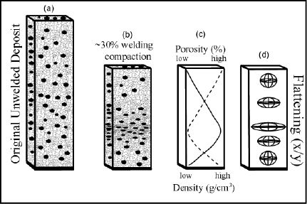
Figure 1. Schematic representation of the welding process. (a) An undeformed pyroclastic flow deposit immediately after deposition comprising Y-shaped ash shards and subspherical pumice lapilli (black) (b) The same deposit after undergoing 30% compaction due to welding. Pumice and shards are flattened. (c) Change in porosity % and density with depth in the welded deposit. Low porosity and high density correspond with the greatest flattening in (b) and occurs 35-40% from the bottom of the deposit. (d) Schematic strain ellipses showing the effects of welding on shape of pumice lapilli. Flattening (x dimension/y dimension) is another means of mapping welding intensity.
Composition and evolution of YukonBTanana Terrane in the Stewart River area, Yukon Territory1
Jim Ryan*2, Steve Gordey2, Mike Villeneuve3 and Steve Piercey4
1Contribution to the Ancient Pacific Margin NATMAP Project
2Geological Survey of Canada, 101-605 Robson St., Vancouver, BC., V6B5J3
3Geological Survey of Canada, 615 Booth Street, ON., K1A 0E8
4Department of Earth Sciences, Laurentian University, Sudbury, ON., P3E 2C6
*jryan@nrcan.gc.ca
Geological mapping in the Stewart River area is a component of the Ancient Pacific Margin NATMAP Project, which seeks to understand the composition, relationships, and metallogeny of poorly understood pericratonic terranes lying between the ancestral North American margin and those known with more certainty to be tectonically accreted.
The Stewart River component of the NATMAP focuses on the YukonBTanana Terrane (YTT), which consists of a twice-transposed and metamorphosed assemblage amphibolite-facies gneisses and schists of mostly(?) Paleozoic age. Looking through the deformation and metamorphism to dtermine the composition and setting of these rocks is a challenge. The YTT rocks are intruded by younger plutonic rocks (Jurrassic, Cretaceous and Eocene) and overlain by late Cretaceous volcanic rocks. Metasiliciclastic rocks are widespread, and dominated by psammite and quartzite, with lesser pelities and rare conglomerate. The siliclastic rocks have been thought to be as old as late Proterozoic; however, preliminary detrital zircon geochronology and geochronology for plutonic rocks constrain them to be Devono-Mississippian. Intermediate to mafic composition amphibolites (appear to) interdigitate with, and lie stratigraphically above the siliciclastic rocks. Although intensely tectonized, heterogeneous compositional layering and local vestiges of primary textures such as breccia clasts or pillow selvages indicate derivation from volcanic to volcaniclastic rocks. Marble horizons (reefs?) occur within the amphibolites, as well as the siliciclastic rocks. A complex of orthogeissic rocks with diorite, tonalite, granodiorite and mozogranite protoliths, intrude both the siliciclastic and amphibolitic assemblages, and is interpeted as a subvolcanic intrusive complex. Lithologically, the metavolcanic and metaplutonic rocks comprise a typical arc sequence, a setting consistent with our initial geochemical analyses. In particular, amphibolitic rocks have island arc tholeiite (IAT) geochemical signatures, and metaplutonic rocks have calc-alkaline affinities. Preliminary U/Pb zircon geochromology of the plutonic rocks indicate they are part of the regionally widespread Devono-Mississippian magmatic event and likely represent the arc infrastructure to the coeval back-arc basin within the YTT rocks in the Finlayson Lake region. If the 450 km of dextral offset along the Tintina Fault were restored, the Finlayson Lake region would lie immediately to the northeast of the Stewart River area. Plutons of mid-Permian age may belong to another arc succession built upon this mid-Paleozoic substrate. Younger, felsic plutons of Jurassic, Cretaceous and Eocene age have little to no fabric.
The Paleozoic rocks in the field area exhibit a regional foliation (ST), characterized by high-strain transposition of layering in the gneisses and schists, with abundant intrafolial isoclinal folds that are commonly rootless. The intensity of strain within the regional foliation locally grades to mylonite. Primary compositional layering (S0) in metasedimentary rocks, unit contacts (e.g. dyke margins), and a pre-existing foliation (S1) can be recognized around closures of the transposition folds, indicating that they are at least F2 structures. F2 deformation appears to accompany the regional metamorphism, and geochronological results indicate that this happened in the mid-Permian. The F2 folds are generally recumbent to shallowly inclined, close to isoclinal, long-wavelength structures. They commonly lack an axial planar foliation, and their axes parallel a regional extension lineation (L2). This relationship helps distinguish F2 and F3 folds, which can have very similar style. The latter are open, moderately inclined (but varying from shallow to steep), shallowly plunging structures, that have weak axial-planar fabric where developed in schistose layers, and have no associated extension lineation. The map area is also affected by faults of various significance. Most of these could not be observed directly, but are interpreted from changes in rock type, and/or structural grain. Some of these are also well delineated by prominent physiographic and aeromagnetic lineaments. Locally, fault breccia and slickensides provide direct evidence of fault contacts.
A tectonic model is presented to explain the setting and formation of Yukon-Tanana Terrane rocks of the Stewart River in the Devono-Mississippian, their Permian orogenic fabric, and their subsequent tectonic emplacement onto North American stratigraphy in the Jura-Cretaceous.
THE TIGHE CREEK LACCOLITH; A BLISTER ON A SILL
Simony, P.S. and Reid, L.F.
Department of Geology and Geophysics, University of Calgary, Calgary, AB T2N 1N4
The Tighe Creek Laccolith in the Hobson Lake area of the central Cariboo Mountains of British Columbia is one of a suite of small intrusions associated with the Mid-Jurassic Hobson Lake Pluton (Lat. 52° 40' N, Long. 120° 05' W). It is located at the northeastern margin of a belt of Mid-Jurassic plutons in the southern Omineca Belt. The Laccolith was emplaced within the upper Isaac Formation of the Neoproterozoic Cariboo Group. It is a tonalitic feldspar porphyry with 30% to 40% plagioclase phenocrysts in a medium-grained groundmass of plagioclase, quartz, chloritized biotite and minor orthoclase and epidote. The Laccolith is set in a swarm of 1 to 10 m thick sills of the same composition and texture. The sills were intruded sub-parallel to schistosity axial-planar to southwest verging folds that the Laccolith cross-cuts. The local 400 m relief and the regional northeast dip permit substantial three-dimensional control.
The Laccolith rises above a 5 to 10 m thick sill, it has an elliptical base with semi axes of 600 and 400 m, a maximum thickness of 350 m and a volume of some 230 x 106 m3. It was fed by its basal sill through an opening with an effective cross-sectional area of some 6000 m2. Room was created in part by inflation and in part by splitting off screens in the roof. The well established Proterozoic and Paleozoic stratigraphy, and the Jurassic structure of the north-central Cariboo Mountains suggest a depth of emplacement of some 10-15 km. This is consistent with biotite and garnet grade Jurassic regional metamorphism of the country rocks, absence of a chilled margin and narrow to absent hornfelsic margin. The Laccolith is situated at the margin of a complex of Cretaceous deformation and metamorphism but is itself not strongly deformed. Some of the sills are folded and boudiné.
Chemical changes and the development of quartz preferred orientation
in zones of crenulation cleavage, Anglesey.
John Starkey, Vancouver, BC.
Crenulation cleavage is well developed in rocks of the New Harbour Group of Anglesey, North Wales. Modal and chemical analyses, and a study of the crystallographic orientation of quartz grains, indicate significant differences between the microlithons
and the zones of cleavage. The reduction in quartz content and the increase in muscovite observed in the zones of cleavage is accompanied by enrichment in TiO2, Al2O3, Fe2O3, MnO, MgO, K2O and P2O5. Conversely SiO2, CaO and Na2O are depleted. Mass balancecalculations suggest at least a 26% volume decrease in the cleavage
zones.
Quartz-rich layers in the microlithons become attenuated when traced into the cleavage zones and the quartz grains are reduced in size and assume a platy habit. The orientation of the quartz c-axes is weakly preferred within the microlithons but strongly preferred within the cleavage zones with the development of a single point maximum oriented normal to the plane of cleavage in which the quartz plates lie. This is interpreted as the result of the dissolution of quartz during the formation of the crenulation cleavage with the development of lenticular shapes due to the crystallographic control of the solution rates. Mechanical orientation of the lenses parallel to the cleavage is the likely
origin of the preferred crystallographic orientation.
FAULTSLIP: A New Windows Application for Analysing Slickenside and
Earthquake Fault Plane Data
Robert M. Stesky, Pangaea Scientific, Brockville, ON
FaultSlip combines a choice of analytical methods with a handy user interface and a stereonet display to make processing fault slip data easy and productive. The program reads data from a text file and accepts a variety of formats: faults (strike/dip or dip-direction/dip) and slickensides (trend/plunge, trend-only, plunge-only or rake), earthquake nodal planes (strike/dip or dip-direction/dip) or earthquake PT axes (trend/plunge). The fault measurements can be weighted using a user-defined quality factor. The raw data, as well as the available options and current results and
plot, are always available on the screen for easy access. The display options include the ability to show or hide the fault planes, slip directions, movement planes, slip linears, principal stresses and
confidence limits.
The current version of FaultSlip has three plug-in processing modules: a tensor averaging method similar to Spang's; Reches' method using a failure criterion; and Michael's method of minimizing deviations in slip direction. Under development is Gephart & Forsyth's grid search method that, like Michael's, is based on minimizing the deviations in slip direction. Other method modules will be provided as they become available. In all cases, the confidence limits on the principal stress directions are computed using the bootstrap method (also called resampling with replacement). FaultSlip allows the user to choose the confidence level, which changes the number of resamplings and hence the computation time. The bootstrap method makes no assumption about the nature and distribution of the errors.
Instability and localization of deformation in lower crust granulites,
Minas fault zone, Nova Scotia, Canada
Joseph Clancy WhiteDepartment of Geology, University of New Brunswick
Fredericton, NB E3B 5A3
[Previously presented September 2nd 2002, “Transport and Flow Processes in Shear Zones”, Geol. Soc. Lond.]
Blocks of granulite from within the megabreccia at Clarke Head, Nova Scotia, Canada contain extremely well-preserved mylonitic and ultramylonitic textures developed in mineral assemblages for which thermobarometic calculations indicates deformation temperatures and pressures between 700-860° C and 750-950 MPa. Deformation within these rocks is characterized by at several discrete scales associated with the development of new fabrics comprising finer-grained material; that is, as the intensity of deformation increases, the characteristic length scale of localization features (thickness) decreases, but become more numerous, and recrystallized grain size, a proxy for stress, also decreases.
The host mylonitic granulite exhibits dislocation creep microstructures, with development of intense S–C fabrics during the transition to ultramylonite. Dynamically recrystallized plagioclase can be followed progressively to a size on the order of 5µm, but there remain extensive zones with grains less than 1 µm in diameter. Localization of the these finest-grained ultramylonites occurs by transient frictional events induced by elevated fluid pressures where fluids comprise both partial igneous melts and pseudotachylyte and makes possible abrupt decreases in grain size that are not anticipated during dislocation creep.
Behaviour of these rocks demonstrates the inherent heterogeneity of deformation wherein characteristic length scales must be considered when assigning evidence from the rock record (e.g. paleopiezometry) to bulk behaviour of the lithosphere. Associated with this softening, is the common obliteration of microstructures formed during the transient trigger event that initiated the instability leading to strain localization. The absence of such microstructural evidence can reconcile contradictions in the rock record, such as production of ultra-fine-grained superplastic aggregates in what otherwise appears to be a dominantly dislocation creep regime.
Interaction of brittle and ductile processes in upper-crustal fault zones
Paul Wilson and Joseph Clancy White
Department of Geology, University of New Brunswick, PO Box 4400,
Fredericton, New Brunswick, CANADA E3B 5A3
[Previously presented September 3rd 2002, “Transport and Flow Processes in Shear Zones”, Geol. Soc. Lond.]
Deformation exerts distinct controls on the evolution of fluid-flow behaviour through its impact on porosity and permeability. Hence, deformation mechanisms are critical to our understanding of fluid-flow processes in shear zones, hydrothermal systems, and hydrocarbon migration and trapping processes. Transmitted light, cathodoluminescence (CL) and electron microscope techniques have been used to infer deformation mechanisms for upper-crustal fault rocks collected from the Moncton basin of New Brunswick, Canada, and from the Denali fault zone in Yukon Territory, Canada. Faults in the Moncton basin are regionally important basin-controlling faults, while the Denali fault zone is a 2000 km-long strike-slip terrane boundary.
Fault rocks collected from New Brunswick are characteristically fault breccias cemented with calcite veins. Transmitted light and CL observations indicate that several generations of vein are present. In many cases samples contain quartz fragments which show evidence for crystal-plastic behaviour. Samples from the Denali fault zone are characterised by the ubiquitous presence of carbonate and carbonate/quartz veins. The veins almost invariably show intense ductile deformation characterised by extensive crystal plasticity and dynamic recrystallisation, culminating in the formation of mylonites and ultramylonites. In some samples mylonites derived from deformation of carbonate veins are brecciated, showing a complete range between intensely ductile and intensely brittle deformation. CL observations show that clasts from some fault breccia samples contain numerous generations of veins.
It is suggested that fault rocks from both areas formed through similar processes, but that the Denali fault is a more evolved fault zone than those examined in the Moncton Basin. We envisage interaction between brittle processes (vein formation, brecciation and hydrofracturing) and ductile processes (crystal plasticity and dynamic recrystallisation) during upper-crustal deformation. Veins are better able to deform plastically than their wall rocks because they are initially strain free, because they may consist of weaker minerals (e.g. carbonates), and because they may be coarser-grained than wall rocks (resulting in less rapid strain hardening). Thus carbonate veins formed through brittle processes localise ductile deformation and may become ductile shear zones. Ductile processes are an increasingly important factor in upper-crustal deformation as fault zones become more evolved and exhibit higher strains.